
Dosya:Tectonic Map of Turkey.png
Bu önizlemenin boyutu: 800 × 441 piksel. Diğer çözünürlükler: 320 × 176 piksel | 640 × 353 piksel | 1.102 × 607 piksel.
Tam çözünürlük ((1.102 × 607 piksel, dosya boyutu: 64 KB, MIME tipi: image/png))
Bu dosya Wikimedia Commons'ta bulunmaktadır. Dosyanın açıklaması aşağıda gösterilmiştir. Commons, serbest/özgür telifli medya dosyalarının bulundurulduğu depodur. Siz de yardım edebilirsiniz. |
| Açıklama |
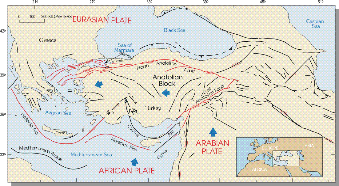
English: The tectonic map of Turkey, including “the North Anatolian fault, East Anatolian fault, and Hellenic and Florence trenches. The westward movement of the Anatolian block results from (1) differences in rates of motion between the Arabian and African plates, (2) different directions of motion between the Anatolian block and Eurasian plate to the north, and (3) subduction of the African plate beneath the Anatolian block at the Hellenic and Florence trenches. The Arabian plate is moving to the north faster than the African plate, both relative to a stable Eurasian plate. The result is a westward moving wedge incorporating most of Turkey.”
Magyar: Törökország tektonikai térképe |
|||
| Tarih | ||||
| Kaynak | U.S. Geological Survey, National Earthquake Information Center | |||
| Yazar | U.S. Geological Survey, National Earthquake Information Center | |||
| İzin (Bu dosyanın tekrar kullanımı) |
|
|||
| Diğer sürümler | File:West-turkey-plates-cropped.gif, File:Turkey-plates-cropped.gif |
Dosya geçmişi
Dosyanın herhangi bir zamandaki hâli için ilgili tarih/saat kısmına tıklayın.
| Tarih/Saat | Küçük resim | Boyutlar | Kullanıcı | Yorum | |
|---|---|---|---|---|---|
| güncel | 23.03, 4 Temmuz 2014 | | 1.102 × 607 (64 KB) | Regasterios | {{Information |Description ={{en|1=Tectonic Map of Turkey}} {{hu|1=Törökország tektonikai térképe}} |Source =http://web.archive.org/web/20101228194237/http://neic.usgs.gov/neis/eq_depot/2003/eq_030501/neic_tgac_maps.html |Author... |
Dosya kullanımı
Bu görüntü dosyasına bağlantısı olan sayfalar:
Küresel dosya kullanımı
Aşağıdaki diğer vikiler bu dosyayı kullanır:
- en.wikipedia.org üzerinde kullanımı
- hu.wikipedia.org üzerinde kullanımı
- hy.wikipedia.org üzerinde kullanımı
- ru.wikipedia.org üzerinde kullanımı
- ru.wikinews.org üzerinde kullanımı