
Dosya:Rockford-Freeport-Rochelle CSA.png
Daha yüksek çözünürlüğe sahip sürüm bulunmamaktadır.
Rockford-Freeport-Rochelle_CSA.png ((298 × 494 piksel, dosya boyutu: 20 KB, MIME tipi: image/png))
Bu dosya Wikimedia Commons'ta bulunmaktadır. Dosyanın açıklaması aşağıda gösterilmiştir. Commons, serbest/özgür telifli medya dosyalarının bulundurulduğu depodur. Siz de yardım edebilirsiniz. |
| Açıklama |
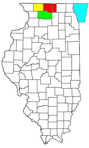
Locator map of the Rockford-Freeport-Rochelle Combined Statistical Area in the central part of the U.S. state of Illinois. The three components of the CSA are colored separately: |
||
| Tarih | |||
| Kaynak |
Modified from this United States Census Bureau file, based on the following Census definitions lists: |
||
| Yazar | User:Nyttend | ||
| İzin (Bu dosyanın tekrar kullanımı) |
US Government work is public domain, and my work is
|
Dosya geçmişi
Dosyanın herhangi bir zamandaki hâli için ilgili tarih/saat kısmına tıklayın.
| Tarih/Saat | Küçük resim | Boyutlar | Kullanıcı | Yorum | |
|---|---|---|---|---|---|
| güncel | 15.05, 30 Temmuz 2008 | | 298 × 494 (20 KB) | Nyttend | {{Information |Description=Locator map of the {{w|Rockford metropolitan area|Rockford-Freeport-Rochelle}} {{w|Combined Statistical Area}} in the central part of the {{w|U.S. state}} of {{w|Illinois}}. The three components of the CSA are colored separatel |
Dosya kullanımı
Bu görüntü dosyasına bağlantısı olan sayfalar:
Küresel dosya kullanımı
Aşağıdaki diğer vikiler bu dosyayı kullanır:
- de.wikipedia.org üzerinde kullanımı
- es.wikipedia.org üzerinde kullanımı