
Dosya:Pinus ponderosa subspecies range map.png
Bu önizlemenin boyutu: 489 × 599 piksel. Diğer çözünürlükler: 196 × 240 piksel | 609 × 746 piksel.
Tam çözünürlük ((609 × 746 piksel, dosya boyutu: 77 KB, MIME tipi: image/png))
Bu dosya Wikimedia Commons'ta bulunmaktadır. Dosyanın açıklaması aşağıda gösterilmiştir. Commons, serbest/özgür telifli medya dosyalarının bulundurulduğu depodur. Siz de yardım edebilirsiniz. |
| Açıklama |
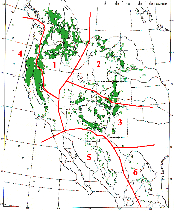
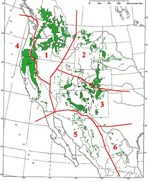
Range map of Pinus ponderosa and Pinus arizonica
|
|||
| Tarih | ||||
| Kaynak | Base map (black outlines & green range map) is from USDA Forest Service Misc,.Publ. 991 (public domain-USGov); red delineation is my work, which I release into public domain | |||
| Yazar | MPF | |||
| İzin (Bu dosyanın tekrar kullanımı) |
|
Dosya geçmişi
Dosyanın herhangi bir zamandaki hâli için ilgili tarih/saat kısmına tıklayın.
| Tarih/Saat | Küçük resim | Boyutlar | Kullanıcı | Yorum | |
|---|---|---|---|---|---|
| güncel | 14.09, 7 Aralık 2009 | | 609 × 746 (77 KB) | MPF | {{Information |Description=Range map of ''Pinus ponderosa'' and ''Pinus arizonica'' # ''Pinus ponderosa'' subsp. ''ponderosa'' - North Plateau Ponderosa Pine # ''Pinus ponderosa'' subsp. ''scopulorum'' - Rocky Mts Ponderosa Pine # ''Pinus ponderos |
Dosya kullanımı
Bu görüntü dosyasına bağlantısı olan sayfalar:
Küresel dosya kullanımı
Aşağıdaki diğer vikiler bu dosyayı kullanır:
- arz.wikipedia.org üzerinde kullanımı
- ca.wikipedia.org üzerinde kullanımı
- cs.wikipedia.org üzerinde kullanımı
- el.wikipedia.org üzerinde kullanımı
- es.wikipedia.org üzerinde kullanımı
- ha.wikipedia.org üzerinde kullanımı
- id.wikipedia.org üzerinde kullanımı
- nl.wikipedia.org üzerinde kullanımı
- pl.wikipedia.org üzerinde kullanımı
- pt.wikipedia.org üzerinde kullanımı
- sv.wikipedia.org üzerinde kullanımı
- uk.wikipedia.org üzerinde kullanımı
- www.wikidata.org üzerinde kullanımı