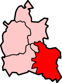
Dosya:OxfordshireSouth.png
Görünüm
OxfordshireSouth.png ((200 × 267 piksel, dosya boyutu: 16 KB, MIME tipi: image/png))
Dosya geçmişi
Dosyanın herhangi bir zamandaki hâli için ilgili tarih/saat kısmına tıklayın.
| Tarih/Saat | Küçük resim | Boyutlar | Kullanıcı | Yorum | |
|---|---|---|---|---|---|
| güncel | 23.25, 29 Temmuz 2005 |  | 200 × 267 (16 KB) | Cnyborg | South Oxfordshire i Oxfordshire, England. From en:Image:OxfordshireSouth.png by en:User:Morwen {{GFDL-en}} |
Dosya kullanımı
Bu görüntü dosyasına bağlantısı olan sayfalar:
Küresel dosya kullanımı
Aşağıdaki diğer vikiler bu dosyayı kullanır:
- de.wikipedia.org üzerinde kullanımı
- en.wikipedia.org üzerinde kullanımı
- Henley-on-Thames
- Wallingford, Oxfordshire
- Garsington
- Didcot
- Thame
- Towersey
- South Oxfordshire
- Elsfield
- Dorchester on Thames
- Brightwell-cum-Sotwell
- Goring-on-Thames
- Shotover
- Whitchurch-on-Thames
- Culham
- Roke
- Wantage (UK Parliament constituency)
- Henley (UK Parliament constituency)
- Shiplake
- Nettlebed
- Crowmarsh Gifford
- Benson, Oxfordshire
- Sonning Eye
- Cholsey
- Waterstock
- Ewelme
- Berrick Salome
- Adwell
- Watlington, Oxfordshire
- Wheatley, Oxfordshire
- South Stoke, Oxfordshire
- Great Milton
- Clifton Hampden
- Chinnor
- Pishill
- Aston Tirrold
- Aston Upthorpe
- Aston Rowant
- Beckley and Stowood
- Berinsfield
- Binfield Heath
- Bix and Assendon
- Henley Rural District
- Rotherfield Greys
- Waterperry
- Playhatch
- Dunsden Green
- Sandford-on-Thames
- Bullingdon Rural District
- Culham Rural District
Bu dosyanın daha fazla küresel kullanımını görüntüle.


