
Dosya:Mexico cartel map May 2010.svg

Bu SVG dosyasının PNG önizlemesinin boyutu: 800 × 544 piksel. Diğer çözünürlükler: 320 × 218 piksel | 640 × 435 piksel | 1.024 × 696 piksel | 1.280 × 870 piksel | 2.560 × 1.741 piksel | 1.000 × 680 piksel.
Tam çözünürlük (SVG dosyası, sözde 1.000 × 680 piksel, dosya boyutu: 193 KB)
Bu dosya Wikimedia Commons'ta bulunmaktadır. Dosyanın açıklaması aşağıda gösterilmiştir. Commons, serbest/özgür telifli medya dosyalarının bulundurulduğu depodur. Siz de yardım edebilirsiniz. |
| Açıklama |
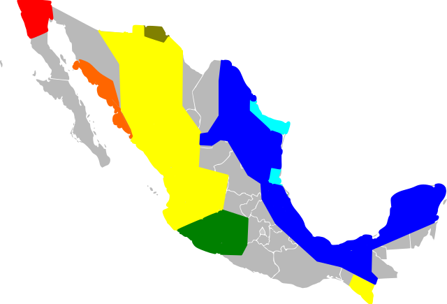
English: An approximate map of the areas held by various Mexican cartels. This map was generated using the information at [1], based on [2] (STRATFOR report dated May 17, 2010). Some points from that map were roughly located and used to draw line segments, from which the territories were filled. Note that the method of simply sampling individual location datapoints from a map precludes all possibility of copyright, and my experience trying to control Inkscape was so poor I feel like I couldn't violate copyright with it if I wanted to! Red = Tijuana/Arellano Felix, Orange = Beltran Leyva, Yellow=Sinaloa, Green=La Familia/Michoacan, Brown=Carillo Fuentes, Cyan=Gulf Cartel/New Federation, Blue=Zetas. Note that this data was likely never very reliable, has been further degraded by my method of redrawing the map, and is surely out of date as of the time I uploaded it. Last but not least, be warned this Inkscape monstrosity may not act like proper svg and could end up not displaying the way it did on my screen. |
| Tarih | (UTC) |
| Kaynak | |
| Yazar |
|
![[1]](http://www.wickenburg-az.com/wp-content/uploads/2010/11/Smuggling_1-4.jpg)
Ben, bu işin telif sahibi, burada işi aşağıdaki lisanslar altında yayımlıyorum:
Bu dosya, Creative Commons Atıf-Benzer Paylaşım 3.0 Taşınmamış lisansı ile lisanslanmıştır
- Şu seçeneklerde özgürsünüz:
- paylaşım – eser paylaşımı, dağıtımı ve iletimi
- içeriği değiştirip uyarlama – eser adaptasyonu
- Aşağıdaki koşullar geçerli olacaktır:
- atıf – Esere yazar veya lisans sahibi tarafından belirtilen (ancak sizi ya da eseri kullanımınızı desteklediklerini ileri sürmeyecek bir) şekilde atıfta bulunmalısınız.
- benzer paylaşım – Maddeyi yeniden düzenler, dönüştürür veya inşa ederseniz, katkılarınızı özgünüyle aynı veya uyumlu lisans altında dağıtmanız gerekir.

|
Bu belgenin GNU Özgür Belgeleme Lisansı, Sürüm 1.2 veya Özgür Yazılım Vakfı tarafından yayımlanan sonraki herhangi bir sürüm şartları altında bu belgenin kopyalanması, dağıtılması ve/veya değiştirilmesi için izin verilmiştir;
Değişmeyen Bölümler, Ön Kapak Metinleri ve Arka Kapak Metinleri yoktur. Lisansın bir kopyası GNU Özgür Belgeleme Lisansı sayfasında yer almaktadır. |
İstediğiniz lisansı seçebilirsiniz.
Orijinal yükleme günlüğü
This image is a derivative work of the following images:
- File:Mexico_Map.svg licensed with Cc-by-sa-3.0, GFDL
- 2009-04-27T09:22:54Z Allstrak 1000x680 (151067 Bytes) {{Information |Description={{en|1=a gray map of the states of Mexico to use as template for other Maps}} {{nl|1=een grijze kaart van de staten van Mexico om te gebruiken als 'template' om ander kaarten op te bazeren}} |Source
Uploaded with derivativeFX
Dosya geçmişi
Dosyanın herhangi bir zamandaki hâli için ilgili tarih/saat kısmına tıklayın.
| Tarih/Saat | Küçük resim | Boyutlar | Kullanıcı | Yorum | |
|---|---|---|---|---|---|
| güncel | 09.03, 21 Mart 2011 | | 1.000 × 680 (193 KB) | Wnt | {{Information |Description={{en|1=An approximate map of the areas held by various Mexican cartels. This map was generated using the information at [http://www.wickenburg-az.com/wp-content/uploads/2010/11/Smuggling_1-4.jpg], based on [http://www.stratfor. |
Dosya kullanımı
Bu görüntü dosyasına bağlantısı olan sayfalar:
Küresel dosya kullanımı
Aşağıdaki diğer vikiler bu dosyayı kullanır:
- af.wikipedia.org üzerinde kullanımı
- ast.wikipedia.org üzerinde kullanımı
- cs.wikipedia.org üzerinde kullanımı
- en.wikipedia.org üzerinde kullanımı
- es.wikipedia.org üzerinde kullanımı
- eu.wikipedia.org üzerinde kullanımı
- hy.wikipedia.org üzerinde kullanımı
- it.wikipedia.org üzerinde kullanımı
- ja.wikipedia.org üzerinde kullanımı
- ka.wikipedia.org üzerinde kullanımı
- ko.wikipedia.org üzerinde kullanımı
- pl.wikipedia.org üzerinde kullanımı
- ro.wikipedia.org üzerinde kullanımı
- ru.wikipedia.org üzerinde kullanımı
- ru.wikinews.org üzerinde kullanımı
- sk.wikipedia.org üzerinde kullanımı
- sr.wikipedia.org üzerinde kullanımı
- uk.wikipedia.org üzerinde kullanımı