
Dosya:Mbini.PNG
Tam çözünürlük ((1.918 × 1.382 piksel, dosya boyutu: 998 KB, MIME tipi: image/png))
Bu dosya Wikimedia Commons'ta bulunmaktadır. Dosyanın açıklaması aşağıda gösterilmiştir. Commons, serbest/özgür telifli medya dosyalarının bulundurulduğu depodur. Siz de yardım edebilirsiniz. |
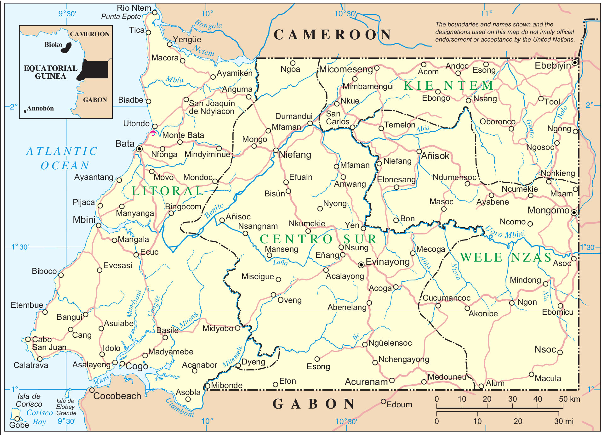
Mapa de Mbini. Guinea Ecuatorial
| This image is a map derived from a United Nations map.
Unless stated otherwise, UN maps are to be considered in the public domain. This applies worldwide. UN maps are, in principle, open source material and you can use them in your work or for making your own map. UN requests however that you delete the UN name, logo and reference number upon any modification to the map. Content of your map will be your responsibility. You can state in your publication, if you wish, something like: based on UN map … (map name, map number, revision number and date). See: Geospatial Information Section. And: Geospatial, location data for a better world. |
 |
Fuente: http://www.un.org/Depts/Cartographic/map/profile/eqguinea.pdf
Dosya geçmişi
Dosyanın herhangi bir zamandaki hâli için ilgili tarih/saat kısmına tıklayın.
| Tarih/Saat | Küçük resim | Boyutlar | Kullanıcı | Yorum | |
|---|---|---|---|---|---|
| güncel | 11.12, 7 Eylül 2014 | | 1.918 × 1.382 (998 KB) | Basquetteur | Higher resolution map |
| 03.49, 20 Mayıs 2005 |  | 844 × 606 (142 KB) | Taichi | Mapa de Mbini. Guinea Ecuatorial {{PD}} Fuente: http://www.un.org/Depts/Cartographic/map/profile/eqguinea.pdf |
Dosya kullanımı
Bu görüntü dosyasına bağlantısı olan sayfalar:
Küresel dosya kullanımı
Aşağıdaki diğer vikiler bu dosyayı kullanır:
- af.wikipedia.org üzerinde kullanımı
- an.wikipedia.org üzerinde kullanımı
- ast.wikipedia.org üzerinde kullanımı
- bg.wikipedia.org üzerinde kullanımı
- ca.wikipedia.org üzerinde kullanımı
- de.wikipedia.org üzerinde kullanımı
- de.wikivoyage.org üzerinde kullanımı
- en.wikipedia.org üzerinde kullanımı
- eo.wikipedia.org üzerinde kullanımı
- es.wikipedia.org üzerinde kullanımı
- eu.wikipedia.org üzerinde kullanımı
- ff.wikipedia.org üzerinde kullanımı
- fi.wikipedia.org üzerinde kullanımı
- fr.wikipedia.org üzerinde kullanımı
- fr.wiktionary.org üzerinde kullanımı
- gl.wikipedia.org üzerinde kullanımı
- ha.wikipedia.org üzerinde kullanımı
- hr.wikipedia.org üzerinde kullanımı
- ig.wikipedia.org üzerinde kullanımı
- it.wikipedia.org üzerinde kullanımı
- it.wikivoyage.org üzerinde kullanımı
- ja.wikipedia.org üzerinde kullanımı
- ka.wikipedia.org üzerinde kullanımı
- ko.wikipedia.org üzerinde kullanımı
Bu dosyanın daha fazla küresel kullanımını görüntüle.